In the following brief video from CNET we get an exclusive look at the 3D aerial cameras used to build Google Maps’ new Immersive View feature, which shows a realistic view of your route, as well as traffic and weather conditions.

In the following brief video from CNET we get an exclusive look at the 3D aerial cameras used to build Google Maps’ new Immersive View feature, which shows a realistic view of your route, as well as traffic and weather conditions.
What3words helps out when street addresses just aren’t enough. It might be built in to your next car.
New York, NY – May 3, 2018 (PRNewswire) Startling new maps from the Anti-Discrimination Center vividly show the depth and breadth of residential segregation in the United States. Powered by Social Explorer, the maps allow the public to explore at the state, county, census tract, and census block group levels. Fifty years after the passage of the Fair Housing Act, residential segregation remains a fixture in American life.
![]()
These interactive maps uncover extreme segregation in ways that most previous mapping has not. Maps of the African American and Latino populations highlight areas of disproportionately low and disproportionately high concentrations of those respective groups, allowing a clear picture to emerge of the longstanding phenomenon of residential segregation.
As explained by Craig Gurian, Anti-Discrimination Center’s executive director, “While much progress towards integrating different communities has been made since 1968, the sad truth is that when you’re examining residential segregation in the United States 50 years on, areas of pronounced segregation persist all over the country.”
Built using data from the 2010 Census and the 2016 American Community Survey, the maps offer new context and detail about where African American and Latino populations live. The maps spotlight areas of group concentration and absences, showing the extent of segregation patterns and how they vary from place to place.
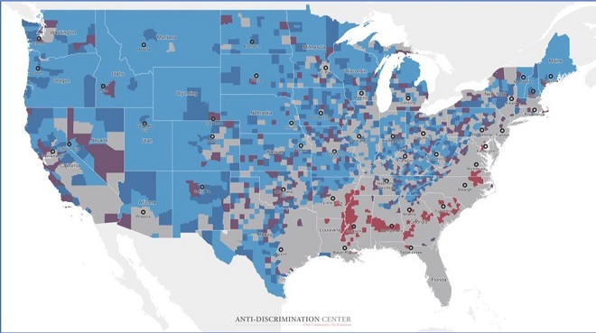
Users can navigate to a particular location on the map by using the geography search box, the panning feature, and the zoom tools. These map explorations illustrate the reach of segregation both across the nation and down to the level of specific neighborhoods.
Visit the Anti-Discrimination Center, a 501(c)(3) not-for-profit civil rights organization dedicated to the vision of “one community, no exclusion,” to start exploring the maps.
About Social Explorer (www.SocialExplorer.com)
Social Explorer, Inc. makes large, complex datasets simple to use and easy to understand. With the help of National Science Foundation grants, the company was founded in 1999 to empower users to explore maps and data online and to present complicated information in a meaningful way. Today we serve millions of end users with dynamic maps, charts and reports. We offer both ready-made solutions and customized client services from content to design to testing to launch and support. Customers include Pearson Publishing, the New York Times and the Census Bureau. Hundreds of university and college libraries subscribe to Social Explorer through our distribution partner Oxford University Press.
Honors include the 2017 Charleston Advisor’s Readers’ Choice Award for Best New Product, the 2016 Webby Award for Best Law Website (Threat to Representation of Children and Non-Citizens), a 2015 Webby Honoree for Best Government website (Census Explorer: Young Adults Then and Now), a 2014 Webby Honoree for Best Education website, the Gold Medal in the 2015 Modern Library Awards, the 2013 Interactive Media Award for Outstanding Achievement for Reference, the 2012 Standard of Excellence Award from the Web Marketing Association, and the 2010 Outstanding Reference Source Award from the Reference and User Services Association (a division of the American Library Association).
Contact:
Craig Gurian
Executive Director, Anti-Discrimination Center
(212) 537-5824 x5